Do trees improve mental wellbeing and reduce stress?
12th October 2020
AWA Tree Consultants: continue to provide tree surveys for planning.
7th January 2021Why would you need tree surveys in Lincolnshire?

Lincolnshire-Trees

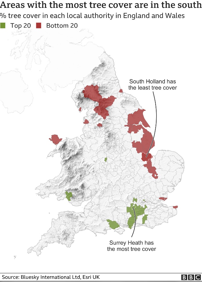
Lincolnshire was described in a BBC article this week as having the lowest tree cover in the county. But is this accurate? From our experience of regularly undertaking tree surveys in Lincolnshire, this doesn’t necessarily ring true. We review the claim and critically look at the reasons suggested for Lincolnshire’s low tree cover:
The BBC article “Gardens help towns and cities beat countryside for tree cover” detailed research which estimated the percentage of tree cover in different parts of the country. The article detailed that the area covering the East coast of Lincolnshire up to East Yorkshire has some of the lowest tree cover in the country.
Using aerial photographs, terrain maps and surface maps, with algorithms to work out which objects are trees, and which are not, the researchers created a National Tree Map, which provided the data behind the BBC story.

The article listed the Lincolnshire areas: South Holland, Boston, North Kesteven, East Lindsey, North Lincolnshire and North East Lincolnshire, in the bottom 20 areas as having the lowest tree cover in the county.
While large predominantly agricultural areas, like Lincolnshire, will have fewer trees than many other geographical types, the description of Lincolnshire as having been ‘swept of trees’ did not ring true with our experience of undertaking tree surveys in Lincolnshire.
The BBC article provides an interesting glimpse of our tree cover, and it highlights the importance of privately owned ‘garden trees’ as a key element of the urban forest. However, as always, the map is not the territory, and the findings in the article may be misleading.
Specifically, the BBC article only refers to proportion/percentage of tree cover. There is huge variation in the sizes of the geographic locations used. Those areas in the south east, which tended to dominate the tree-league-table, occupy a much smaller area than the vaster rural areas of Lincolnshire.
Had the article provided detail on number of trees per person in each area and/or the total number of trees in each area, then this would likely have given different results. This may have provided a more balanced picture of tree cover in England. As it is, only referring to percentages of tree cover may have unfairly lumped Lincolnshire as ‘bottom of the class’ when it comes to trees.
The BBC article quotes Dr Paul Brindley, described as an expert in trees and planning, at Sheffield University’s Department of Landscape Architecture. Dr Brindley explains Lincolnshire’s poor results by stating “These areas were swept of trees for farming and have never recovered”.
Suggesting Lincolnshire’s tree cover is the result of heavy-handed farmers inaccurately simplifies the historic environment and character of these areas, which result from millennia of both human and natural factors.
Much of the agricultural land of the Lincolnshire Coast and adjoining areas has been reclaimed from the sea over many centuries. These areas were never heavily forested. In Roman, medieval and post-medieval periods, settlers drained and reclaimed this land from the sea, establishing rich pasture fields for common grazing on the marshes.
Far from being some idealised ‘wildwood’, which was swept away by ignorant farmers, much of what is now Lincolnshire’s coastal area was once in the sea. It is an unfair comparison, of previously wooded areas and rural areas which were previously sea/marsh/fen landscapes, which were never heavily forested.
Taking a closer look at the areas in the top, and bottom, of the BBC tree-league tables, it is noteworthy that those areas at the top are also generally some of the most affluent areas of the country. If you changed the word ‘tree cover’ for ‘wealth’ many of the top 20 areas wouldn’t look much different – generally being comprised of the most prosperous areas surrounding London.
Conversely, parts of Lincolnshire’s coastline are among some of the most deprived areas of the country. Four hundred and twenty neighbourhoods in Lincolnshire have been named among the most deprived in England. North East Lincolnshire is rated 16th most deprived area in England. Likewise, areas of East Lindsey, South Holland, Boston and North Kesteven, experience high levels of deprivation.
Perhaps we should not be surprised that a nation already divided along geo-political and economic lines, may also be divided arboriculturally.
The BBC story concludes with how trees play an important role in the wellbeing of people. Cllr Adam Harrison, of Camden Council, one of the most well treed and most affluent London boroughs, notes how trees “are fantastic for improving mental and physical health”.
Areas that are already poorer, with lower standards of living, and more endemic health issues – particularly mental health– are exactly the areas that should be benefiting from more trees. Unfortunately the article was overly simplistic suggesting towns and cities are good, and rural areas bad, when understanding the complexities of how tree cover is distributed around where people live. The data on which the BBC story is based could lead to a more accurate and nuanced picture of tree cover in the UK. As such, an accurate National Tree Map could be a potentially invaluable resource highlighting how more tree cover could be used to help to improve the health and wellbeing of local communities.


